A map of adjectival forms of place names
« previous post | next post »
In response to Charles Troster's question about a world map showing the adjectival forms of place names, Stephen Powell wrote:
Here's a map of adjective endings for the countries of the world, as suggested by Charles Troster. It was actually very easy to put together using the country data included in Mathematica 6.0; the full code is below.
The key is:
blue = -ese
green = -ian
red = -an
pink = -ish
purple = -i
brown = -er
yellow = -ic
grey = anything else (or Mathematica doesn't know)It's just matching strings, so Thailand is purple, when that obviously isn't an -i suffix. And Mathematica hasn't recognized Kosovo yet, so that's in green along with (the rest of) Serbia.
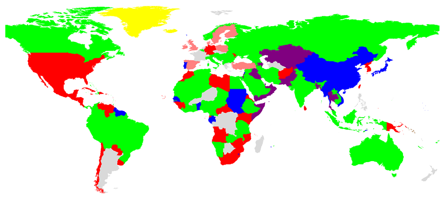
(Click on the map to get a larger version.)
I guess that the adjectival form of Argentina is coded as "Argentine" instead of "Argentinian".
The Mathematica code is below. I'm sorry about the formatting — whenever I save the post, WordPress insists on removing all leading white space. (Stop chortling, Melvyn…)
Graphics[{Function[nat,
If[StringQ[nat],
Pick[{Blue, Green, Red, Pink, Purple, Brown, Yellow, LightGray},
StringMatchQ[nat,
RegularExpression[".+" <> # <> "$"]] & /@ {"ese", "ian",
"an", "ish", "i", "er", "ic", ""}] // First, LightGray]]@
CountryData[#, "NationalityName"], CountryData[#, "Polygon"]} & /@
CountryData[All]]